
cross-posted from: https://lemmy.world/post/28662179
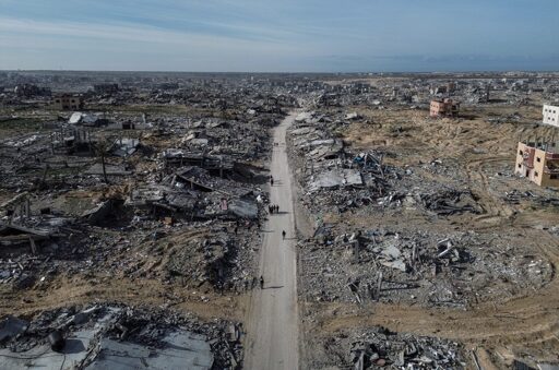
Israel has completely wiped out Rafah, turning a fifth of Gaza’s territory into a giant buffer zone. This is part of Israel’s plan to permanently remain in Gaza and facilitate the ethnic cleansing of its people.
I’d like to see more sources about the complete destruction of Rafah. I haven’t seen e.g. Al Jazeera report on it. Or satellite imagery. Does anyone have links?
Satellite Imagery from the end of August 2024 already shows Rafah being completely destroyed. Here you go: https://www.bellingcat.com/news/2024/08/27/satellite-imagery-shows-vast-destruction-in-rafah/
This is not exactly what you asked for, but it’s the closest thing I can think of. The Forensic Architecture site has some accurate info for Gaza, Palestine but they date back to 2024. Still, I think it’s worth keeping an eye out for any new investigation they might do.
A Cartography of a Genocide
The most recent article about this is from 17 days ago.
https://www.aa.com.tr/en/middle-east/90-of-rafah-s-residential-neighborhoods-destroyed-by-israel-gaza-authorities-say/3529896